Portal:North America
The North America Portal

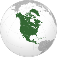
North America is a continent in the Northern and Western Hemispheres. North America is bordered to the north by the Arctic Ocean, to the east by the Atlantic Ocean, to the southeast by South America and the Caribbean Sea, and to the west and south by the Pacific Ocean. Greater North America includes the Bahamas, Bermuda, Canada, the Caribbean, Central America, Clipperton Island, Greenland, Mexico, Saint Pierre and Miquelon, Turks and Caicos Islands, and the United States.
Continental North America covers an area of about 24,709,000 square kilometers (9,540,000 square miles), representing approximately 16.5% of the Earth's land area and 4.8% of its total surface area. It is the third-largest continent by size after Asia and Africa, and the fourth-largest continent by population after Asia, Africa, and Europe. , North America's population was estimated as over 592 million people in 23 independent states, or about 7.5% of the world's population. In human geography, the terms "North America" and "North American" sometimes refer to just Canada, the United States, Mexico, and Greenland.
It is unknown with certainty how and when first human populations first reached North America. People were known to live in the Americas at least 20,000 years ago but various evidence points to possibly earlier dates. The Paleo-Indian period in North America followed the Last Glacial Period, and lasted until about 10,000 years ago when the Archaic period began. The classic stage followed the Archaic period, and lasted from approximately the 6th to 13th centuries. Beginning in 1000 AD, the Norse were the first Europeans to begin exploring and ultimately colonizing areas of North America.
In 1492, the exploratory voyages of Christopher Columbus led to a transatlantic exchange, including migrations of European settlers during the Age of Discovery and the early modern period. Present-day cultural and ethnic patterns reflect interactions between European colonists, indigenous peoples, African slaves, immigrants from Europe, Asia, and descendants of these respective groups. (Full article...)

*A: Cambridge
*B: Newburyport
*C: Fort Western
*D: Fort Halifax
*E: Great Carrying Place
*F: Height of land
*G: Lake Mégantic
This map does not accurately represent the area around the height of land and Lake Mégantic.
In September 1775, early in the American Revolutionary War, Colonel Benedict Arnold led a force of 1,100 Continental Army troops on an expedition from Cambridge in the Province of Massachusetts Bay to the gates of Quebec City. The expedition was part of a two-pronged invasion of the British Province of Quebec, and passed through the wilderness of what is now Maine. The other expedition invaded Quebec from Lake Champlain, led by Richard Montgomery.
Unanticipated problems beset the expedition as soon as it left the last significant colonial outposts in Maine. The portages up the Kennebec River proved grueling, and the boats frequently leaked, ruining gunpowder and spoiling food supplies. More than a third of the men turned back before reaching the height of land between the Kennebec and Chaudière rivers. The areas on either side of the height of land were swampy tangles of lakes and streams, and the traversal was made more difficult by bad weather and inaccurate maps. Many of the troops lacked experience handling boats in white water, which led to the destruction of more boats and supplies in the descent to the Saint Lawrence River via the fast-flowing Chaudière. (Full article...)
Laura Secord (née Ingersoll; 13 September 1775 – 17 October 1868) was a Canadian heroine of the War of 1812. She is known for having walked 20 miles (32 km) out of American-occupied territory in 1813 to warn British forces of an impending American attack. Her contribution to the war was little known during her lifetime, but since her death she has been frequently honoured in Canada. Though Laura Secord had no relation to it, most Canadians associate her with the Laura Secord Chocolates company, named after her on the centennial of her walk.
Laura Secord's father, Thomas Ingersoll, lived in Massachusetts and fought on the side of the Patriots during the Revolutionary War (1775–1783). In 1795 he moved his family to the Niagara region of Upper Canada after he had applied for and received a land grant. Shortly after, Laura married Loyalist James Secord, who was later seriously wounded at the Battle of Queenston Heights early in the War of 1812. While he was still recovering in 1813, the Americans invaded the Niagara Peninsula, including Queenston. During the occupation, Secord acquired information about a planned American attack, and stole away on the morning of 22 June to inform Lieutenant James FitzGibbon in the territory still controlled by the British. The information helped the British and their Mohawk allies repel the invading Americans at the Battle of Beaver Dams. Her effort was forgotten until 1860, when Edward, Prince of Wales, awarded the impoverished widow £100 (£12,955.64 in 2022) for her service on his visit to Canada. (Full article...)The Wells Gray-Clearwater volcanic field, also called the Clearwater Cone Group, is a potentially active monogenetic volcanic field in east-central British Columbia, Canada, located approximately 130 km (81 mi) north of Kamloops. It is situated in the Cariboo Mountains of the Columbia Mountains and on the Quesnel and Shuswap Highlands. As a monogenetic volcanic field, it is a place with numerous small basaltic volcanoes and extensive lava flows.
Most of the Wells Gray-Clearwater volcanic field is encompassed within a large wilderness park called Wells Gray Provincial Park. This 5,405 km2 (2,087 sq mi) park was established in 1939 to protect Helmcken Falls and the unique features of the Clearwater River drainage basin, including this volcanic field. Five roads enter the park and provide views of some of the field's volcanic features. Short hikes lead to several other volcanic features, but some areas are accessible only by aircraft. (Full article...)Did you know...
- ...that in 1869 the Spanish colonial authorities banned Baseball in Cuba because Cubans began to prefer baseball to viewing bullfights, the Spaniards' national sport?
- ... that Vermont coppers (pictured) were the currency used in Vermont before it became a U.S. state in 1791?
- ...that Tropical Storm Larry caused five deaths and US$53.6 million in damage when it struck the Tabasco state of Mexico, the first landfall in the state since 1973?
- ... that the oldest winery in The Americas is in Parras de la Fuente?
- ...that Lucy Hobbs Taylor was the first female dentist in the United States?
Selected panorama

Topics
Categories
List articles
Related portals
Northern America
Central America
Caribbean
WikiProjects
 North America
-
 Canada
 -
 Greenland
 -
 Mexico
 -
 Saint Pierre and Miquelon
 -
 United States
  Central America
-
 Belize
 -
 Costa Rica
 -
 El Salvador
 -
 Guatemala
 -
 Honduras
 -
 Nicaragua
 -
 Panama
  Mesoamerica
 Caribbean
-
 Antigua and Barbuda
 -
 Bahamas
 -
 Barbados
 -
 Bermuda
 -
 Cuba
Cuba -
 Dominica
 -
 Dominican Republic
 -
 Grenada
 -
 Haiti
Haiti -
 Jamaica
 -
 Puerto Rico
 -
 Saint Kitts and Nevis
 -
 Saint Lucia
 -
 Saint Vincent and the Grenadines
 -
 Trinidad and Tobago
Associated Wikimedia
The following Wikimedia Foundation sister projects provide more on this subject:
-
Commons
Free media repository -
Wikibooks
Free textbooks and manuals -
Wikidata
Free knowledge base -
Wikinews
Free-content news -
Wikiquote
Collection of quotations -
Wikisource
Free-content library -
Wikiversity
Free learning tools -
Wikivoyage
Free travel guide -
Wiktionary
Dictionary and thesaurus


